Karl Steddom
Texas Cooperative Extension
 |
|
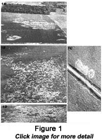
Pictures can be very useful in science and have been so for over seventy-five years. In 1927, pilots with the US Army Air Corps (a former name for the Air Force) told scientists at Texas A&M about large dead areas they had seen in cotton fields near the university. These dead areas were caused by a fungus that attacks the roots of the cotton plants (Phymatotrichum omnivorum). The scientists had been studying this disease but had difficulty measuring how severe the disease was in individual fields. The pilots took one of the scientists up in their plane, and they took photographs of the dead spots. From the photographs, it was easy to measure how much of the cotton in the field had been killed (Fig. 1). Before that, the only way to measure disease incidence was to count the number of cotton plants that had been killed. The photographic evidence of Phymatotrichum root rot was impressive, because humans are very visual in nature. Thus, images convey a great deal of information quickly.
|
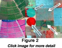 |
During World War I and World War II, the military was actively developing methods to take photographs from airplanes. Aerial photography has been a very useful surveillance method that is relatively safe for personnel. The military developed cameras that were specially designed for aerial imaging over large areas. They also developed special films that were sensitive to infrared light (wavelengths just beyond the range of human sight). During World War II, the military developed camouflage film, also known as color infrared film. This is a color film where green things appear blue, red things appear green, and things that reflect infrared light appear red. With this film, vegetation has a characteristic bright red appearance. Camouflage does not reflect infrared light as well as natural vegetation so it appears blue in color infrared film. During World War II, many soldiers were exposed to this technology. After returning home, they developed many uses for it in agriculture. When camouflage film (color infrared film) is used to take pictures of cropland or forests, it is very easy to identify areas where plants are not growing as well as other areas. This is due to differences in their reflectance (Fig. 2).Healthy leaves reflect green (500 to 600 nanometers) and infrared light (700 nanometers and above) but not blue (400 to 500 nanometers) or red light (600 to 700 nanometers) (Fig. 3). Chlorophyll, the pigment used in photosynthesis, absorbs red and blue light and uses the energy to convert carbon dioxide into plant sugars. Since chlorophyll does not use 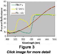 green light, it is reflected and gives healthy leaves their characteristic green color. Near-infrared light is reflected by the spongy cell structure inside of leaves. Chlorotic (yellow) leaves have lower levels of chlorophyll. This may be due to disease or lack of nutrients. Since they do not have much chlorophyll to absorb red and blue light, these leaves reflect more red, blue, and green light than healthy leaves giving them a yellow appearance. Necrotic leaves are leaves that are dead and have turned brown. They do not have pigments or the spongy cell structure of living leaves. Notice how both healthy and chlorotic leaves reflect near-infrared light in Fig.3, but have lower reflection around 700 nanometers. This is known as the “Red Edge” and is characteristic of living leaf tissue.
|
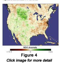 |
Following the space race of the 1960’s, scientists began investigating cameras that could take images from satellites in space. This enabled us to get up-to-the-minute images of weather systems. As the cameras became more sensitive, we could begin to monitor parts of the environment such as forests and grasslands. Scientists have been able to track areas, such as our national forests, and see how the ecosystems change through the year and over time (Fig 4). Camera systems have continued to evolve; cameras can now gather detailed spectral information along with the image (Fig. 5). This type of information allows scientists to identify specific plant communities, identify specific minerals that are located in rock outcroppings, or study the chemical composition of the gasses that are released from volcanoes.
NASA has developed an excellent web site with many articles and images for a wide variety of audiences. Below are links to some areas that are related to this article.
Precision agriculture is the management of large agricultural fields with high resolution. Remote sensing data is very important in this field. You can find out more about precision ag at http://earthobservatory.nasa.gov/Study/PrecisionFarming/ or http://www.precisionag.com/.
Activity
Aerial Photography in Your Schoolyard
Perspective can change how we view things. When we observe the world around us, changing our perspective can give us a more complete picture. Picture the playground at your school, or a nearby park. Perhaps there are areas of dead grass, or areas with lots of weeds. How could you measure how bad the problem is? Walking around the playground will give you an idea, but what if your playground is very large? That might require a lot of time. If we could go up in a helicopter or airplane, we could see the whole playground at once. If we took a camera with us, we could take a picture, and later measure the area showing the problem. Can you think of other ways of getting a camera above your schoolyard? Some people have tied cameras to balloons or kites.
There are numerous web sites where people describe their experiences and how they set their cameras. Some of them are listed below.
|
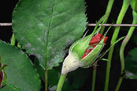 |
Views: The flowers that you send for Mother’s Day would not be as enjoyable if the petals, sepals, or leaves are covered with the grayish white growth of powdery mildew. Powdery mildew is more active as the weather becomes warmer, and it can affect garden as well as commercial roses. Click image for an enlarged view and more information.
|